ETFAS towns: rural architecture in Sardinia through the
archival drawings
Lino Cabras
Fig.
1 - Map of ETFAS settlement centers and autonomous farms
[Source: ETFAS 1962, p. 4]
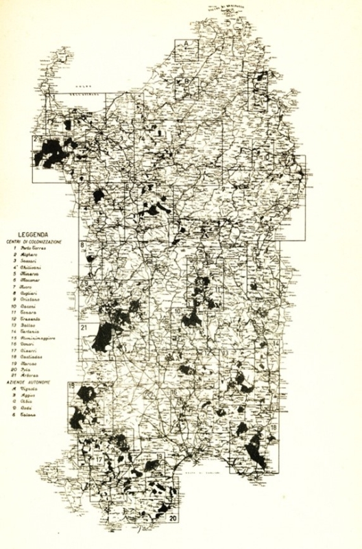
Fig.
2 - Master plan of the town of Porto Conte, L. Figini and G. Pollini
(1953). [Source: Agenzia LAORE Archive, ETFAS fonds].
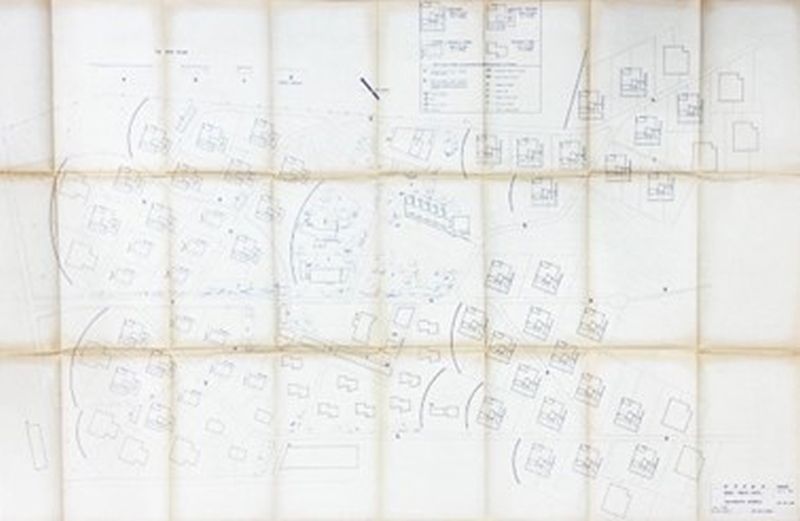
Fig.
3 - Plan and sections of the elementary school in the town of Porto
Conte, L. Figini and G. Pollini (1953).
[Source: Agenzia LAORE Archive, ETFAS fonds].
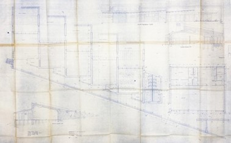
Fig.
4 - Main elevations of the elementary school in the town of Porto
Conte, L. Figini and G. Pollini (1953).
[Source: Agenzia LAORE Archive, ETFAS fonds].
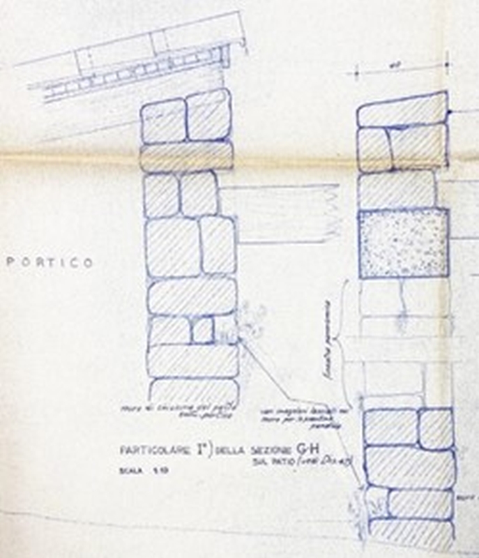
Fig.
5-6 - Construction detail of the primary school in the town of Porto
Conte, L. Figini and G. Pollini (1953).
[Source: Agenzia LAORE Archive, ETFAS fonds].
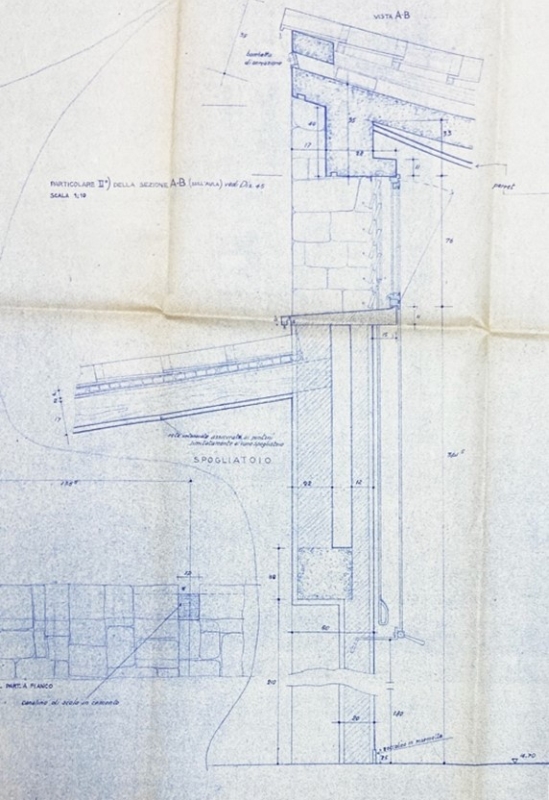
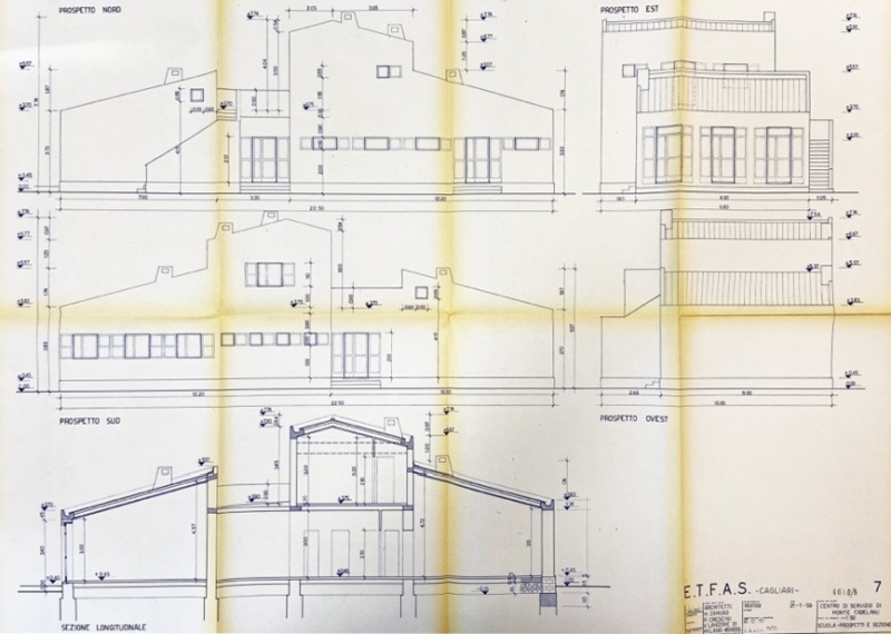
Fig.
7 - Plan for the town of Monte Cadelanu with an alternate (unbuilt)
version of the church, M. Zanuso and P. Crescini (1958).
[Source: Archive of the Modern, ETFAS fonds].
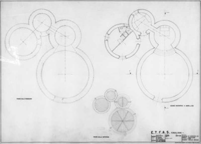
Fig.
8 - Elevations and main section of the school Plan for the town of
Monte Cadelanu, M. Zanuso and P. Crescini (1959).
[Source: Agenzia LAORE Archive, ETFAS fonds].
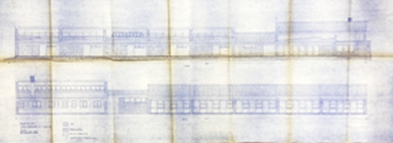
Fig.
9 - Plans of the alternate (unbuilt) version of the church of the town
of Monte Cadelanu, M. Zanuso and P. Crescini (1958).
[Source: Archive of the Modern, ETFAS fonds].
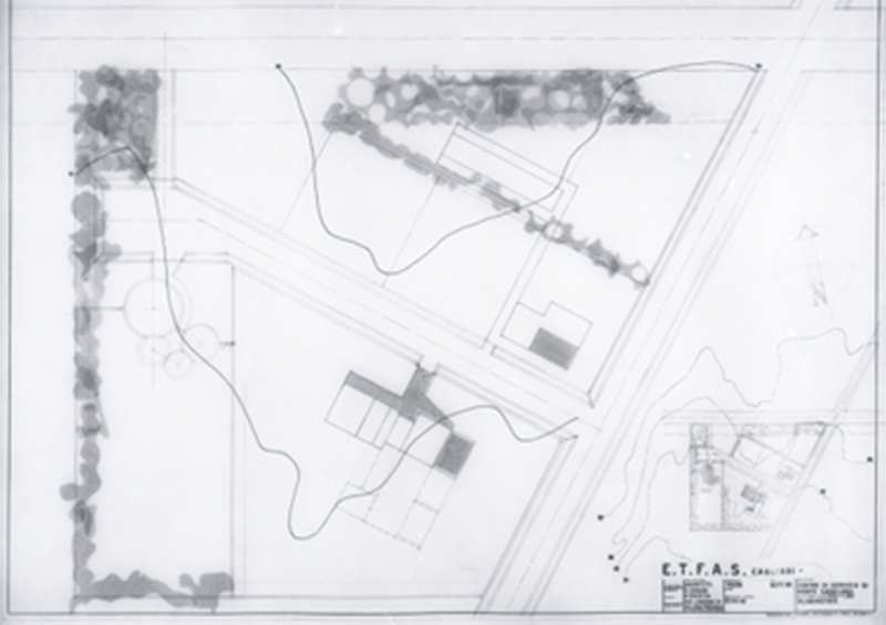
Fig.
10 - Elevation of the main facade of the alternate (unbuilt) version of
the church of the town of Monte Cadelanu, M. Zanuso and P. Crescini
(undated).
[Source: Archive of the Modern, ETFAS fonds].
The surveys published to date on ETFAS towns and service
centers are limited to a small number of contributions mainly
concerning urban and planning aspects[1]; on the other hand, there is a
lack of critical contributions related to architectural projects,
particularly on spaces for education and social life, which constitute
important evidence of single experimentations within the framework of a
programmatic initiative implemented in Sardinia after World War II.
The analysis of the institution’s archival fonds[2] revealed
through the design drawings unexpected spatial and typological
qualities that this paper aims to explore.
- The Authority for Land Use and Agriculture in Sardinia
(Ente per la Trasformazione Fondiaria e Agraria in Sardegna –
ETFAS)[3]
was founded in May 1951 as part of the national land use reform
contained in Italy’s ‘Stralcio Act’. Its
goal was land reclamation and the construction of infrastructure,
farmhouses, towns and centres for improving the lives of the farmer
assignees. However, its primary purpose was to reform agriculture in
the region through a real work of ‘human
transformation’ (ETFAS 1958, p. 6).
The plans for hamlets and towns are characterised by the
provision of shared infrastructure that varies according to the
context, based on the ‘peculiar geographical and
environmental situation of Sardinia, which is rich in very marked zonal
diversities, with profound dissimilarities between even contiguous
areas, created for historical and economic geological
reasons’ (ETFAS 1962, p. 2).
In a fragmented patchwork of about 92 hectares of land (fig.1)
five autonomous farms and twenty-one settlement centers[4] were
established, for which a master plan of services had been planned for
the construction of seven residential towns, thirty-three service
centers[5],
fifty isolated rural schools and fifteen chapels. The residential
hamlets were, however, an exception to the rural settlements planned by
the authority, which were usually of the “scattered
house” type; it therefore became necessary to equip the
territory with service centers for the agrarian inhabitants, to be
located barycentrically to the farms.
The approach to the context, understood as a collection of
land-based, social and economic factors, was the foundation upon which
the designs for these new settlements were developed, starting from the
initial studies carried out by the UN organisation UNRRA CASAS for the
Nurra area, in the implementation of the Sardinian re-population plan
within which the UNRRA interdisciplinary team was working (including
architect Fernando Clemente[6]
and engineer Oreste Noto (Casu 2001).
Despite the fact that the design assumptions were informed by
high standards, especially found in school architectures inspired by
contemporary international experiences (Roth 1950), the ETFAS towns
system encountered a gradual and generalized abandonment by the
allottees, as Di Felice (2005) notes: «already during the
1950s, before the lure of the large factories of the North was felt,
numerous colonial families preferred to abandon the reform lands, while
others were terminated by the same entity».
In the architectural debate of the time, the critical issues
of the new Sardinian rural towns emerge clearly in the words of
Giuseppina Marcialis[7]
(1957):
Settlements rise at considerable distances, separated by
immense expanses of deserted and uncultivated land that offer no direct
possibilities of connection for the time being; moreover, Sardinian
peasants traditionally live in centers in whose community life they
actively participate [...]. Social centers are located in the geometric
center of gravity of a settlement, but often at an excessive distance
from houses [...].
The general plan for the services proposed by the Entity
included the creation of seven residential towns, 33 service centres,
50 isolated rural schools and 15 chapels. The towns and the service
centres had a general zoning framework whose main schema included: a
social centre, a primary school, a nursery school, a retail space, a
post office and barracks.
In just a few years, the town system would come up against its
progressive general abandonment by the assignees, a reflection of the
critical issues detected well in advance by Giuseppina Marcialis (1957)
in relation to the creation of the first clusters:
The inhabited centres are notably far from one another,
separated by immense expanses of deserted and uncultivated land that do
not, for now, offer the direct possibility of connection; moreover,
Sardinian farmers traditionally live in centres where they actively
participate in community life [...]. The social centres are located in
the geometric centre of gravity of a settlement, but often too far from
the homes.
By contrast, archival research has brought to light case
studies that demonstrate all their expressive potential, going well
beyond the meaning of drafts and drawings created as technical
documents in the institutional forms of architectural representation
(plans, elevations and sections).
The first – unrealized[8] – design by Luigi
Figini and Gino Pollini for the town of Porto Conte is presented
exclusively in drawings of public buildings, which make clear the
attention to detail that went into them. The plan was designed on
behalf of ETFAS in the early years of its operation. The executive
drawings of the public buildings denote the extreme attention to
detail, both graphic and textual. The nature of the site and the
reasons for the project are described in the project’s
explanatory report[9]
as follows:
Between the sea and the hilly bumps of reclamation, an attempt
was made to insert the lines and volumes of the plan within the
undulating lines of the landscape in the most natural way, so that it
would almost come to be part of it, in all unity and without
overpowering it; to complete it almost, if possible [...].
The master plan[10],
dated December 1952, (fig.2) represents the entire town in 1:500 scale
with the communal buildings placed at the heart of the village, whose
hierarchies are dictated by the orography of the site. At the lowest
elevation the town’s square is closed to the southwest by a
U-shaped colonnaded building that hosts various businesses: a bakery
for bread, a post office, offices for the town delegation, a medical
clinic and a café; an axis road extends to the northeast
until rising in elevation and reaching the village church, which crowns
the public road upon which the crèche, nursery school, and
primary school are placed crosswise.
The project drawings for educational buildings show the
spatial layout that integrates the interiors with the landscape through
solutions designed to make the teaching spaces flexible through mobile
partitions and niches for various activities. The idea of an outdoor
classroom is a theme that reappears in different ways. In the building
for the crèche, it’s a single space at the end,
determined by an overhead covering and masonry partitions. The same
solution is echoed at the Olivetti crèche in Ivrea[11], while
at the primary school the minimal classroom spaces are conceived of as
an aggregation of staggered cells composed of an indoor room and an
outdoor patio that are grouped one after another, nestled into a
longitudinal portico to mark the edge of the building in the north-west
elevation (fig. 3). A common element seen throughout the
project’s architecture is exposed stonework walls alternating
with walls covered in rustic plaster (fig. 4), as are the pitched roofs
that mark the spaces within the buildings. The volumetric variations
created by the angles of the pitched roofs, as seen in the detail
drawings (fig. 5), have numerous window openings that, with various
solar screen systems and types of windows, make it possible to modulate
the entry of natural light and ensure the circulation of air in the
rooms. These detailed drawings also provide a few precious indications
as ‘irregular compartments left in the wall for pendulous
plantings’ and ‘panoramic windows’[12] (fig.
6) in the patio that, positioned at various heights, unite the built
environment and the natural one[13].
Archival research has also brought to light the preparatory
documents for the unpublished plan[14] built for the ETFAS service
centre in Monte Cadelanu[15],
part of the Cixerri Settlement (fig. 7), by Marco Zanuso and Pietro
Crescini[16].
The ETFAS fonds stores the folder with the executive plan
containing heliographic copies of documents and drawings, dated between
January and December of 1959, of the executive project with the
heliographies, while the Archive of the Modern of the Architecture
Academy of Mendrisio holds in the Zanuso fonds[17] nine graphic works (on
microfilm cells stored on aperture cards)[18] dated between September 1958
and May 1959. The project, completed after 1962, belongs to the last
phase of ETFAS construction works and is built on a flat area bordered
by rows of wind-breaking trees in the direction of the Mistral. The
service centre includes a small school with a single classroom, plus a
library and lodging for the teacher, a market and a church.
The school[19]
(fig. 8) is distinguished by its domestic dimension and again, as found
in almost all ETFAS schools, prioritizes continuity with the
surrounding context:
[...] In the two heads, the southeastern side of the building
contains the teaching room overlooking a large raised square for
outdoor teaching, and the northwestern side contains the library and
meeting room with a separate entrance [...], around the building a
large trapezoidal-shaped space available for games and practical
gardening exercises [20].
A rather unique variation (compared to the other buildings)
was previously designed for the church, made up of multiple spaces with
circular floor plans (fig. 9), evoking a probable archetype of Nuragic
villages[21].
Four secant conical volumes[22]
of varied heights are arranged in pairs: in the first, the space for
the faithful is connected via its central axis with the area containing
the altar raised on a three-step platform, while the second group,
rotated compared to the first which is on the south-eastern side,
holds, respectively, the sacristy and the priest’s living
quarters, complete with an independent entrance from outside. An ample
portal, offset compared to the central axis of the main body, serves as
the entry point to the church, almost as if in search of a relationship
with the side of the forecourt overlooking the other community
buildings. The vertical surfaces of the volumes extend upward, hiding
sunken wooden roofs that are thus invisible from the outside and are
marked by radial vertical slits that extend into concave overhanging
gutter spouts to redirect rainwater.
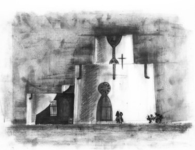
The graphic representation that best embodies this version of
the church is the elevation without a title block (fig. 9), most likely
in graphite, in which the evocative strength of the drawing enabled the
viewer to imagine slices of life embodied by the two presumably female
figures that walk toward the entrance, which is composed of a pointed
arch topped by a rosette. In the esoteric drawing, it is still possible
to contextualise the work in the Sardinian landscape, though quite
abstract, through what seem to be two prickly pear cacti.
The two projects for Porto Conte and Monte Cadelanu presented
herein are testimony to the expression of post-WWII modernism, whose
style incorporated codified rural elements in an effort to re-establish
dialogue with the landscape. The narrative suggestions expressed by the
architects through graphic marks, which open up to an interpretation
that runs parallel to the need to respond to the constructive procedure
for which they were produced, are meaningful, composing far-reaching
images and visions for the community that soon would inhabit those
places.
Notes
[1]
For an in-depth analysis about the urbanistic events of ETFAS see Casu
2001a, and Casu 2001b. For a broader historical overview of land reform
in Sardinia, see Di Felice 2005.
[2]
The ETFAS fonds, deposited at the LAORE Agency in Cagliari, is
currently available for consultation. It has no chronological order;
the only accompanying tool produced during the census phase is a
general archive consistency list in which chronological details and
title related to the original preservation unit are indicated. There
has been no digitization of the documentary material, with the
exception of a few drawing boards of religious architecture published
as part of the Ministry of Culture’s Architectures
of the Second Century census on the platform http://architetturecontemporanee.beniculturali.it/architetture/
[Last accessed August 21, 2022].
The archive is not included in the SIUSA database.
[3]
ETFAS was formed in May 1951, as a result of the national land use
reform approved by Italian Parliament with law n. 841 of 21.10.1950,
known as the ‘Stralcio Act’ (Legge Stralcio) or the
‘Segni Act’ (Legge Segni).
[4]
The map drawn up by the Authority shows the uneven distribution of
acquired land – fielded in black – in
which the settlement centers fall, marked by progressive numbers called
out in legends and geometric perimeters indicating their area of
influence. Autonomous farms, on the other hand, are marked by letters
of the alphabet.
[5]
For the towns and service centers actually implemented, see ETFAS 1962,
p. 41.
[6]
Fernando Clemente (1917-1998) was a student of G. Michelucci, from whom
he learned of Lewis Mumford’s principles of
‘neighbourhood units’ and the requests of the
Movimento Comunità (Community Movement) founded by Adriano Olivetti,
eventually applying them to his designs for ETFAS. Along with Oreste
Noto, Clemente created the town of Tottubella (1953-56) in the
settlement centre of Sassari. See Casu 2001a, p. 65.
[7]
Giuseppina Marcialis (1933-2018) graduated from the Polytechnic
University of Milan with a degree in architecture that same year. She
was a teacher in addition to an architect and urban planner, getting
her start in Rome as the assistant to Piccinato and Benevolo, then in
Florence as an outside lecturer. She filled that same role at the IUAV
University of Venice starting in 1976, which she joined in 1975 as Vice
Chancellor.
[8]
The plan, drawn up on behalf of UNRRA CASAS, was meant to meet the
settlement needs of the refugees of the Istrian-Dalmatian exodus on the
island, leaving to ETFAS the sole assignment of land and the creation
of public buildings, as can be learned from Deliberation no. 208 dated
21 September 1952 (LAORE Archive, ETFAS fonds, sh. E, fold.
n°27). For more on the Porto Conte plan by Figini and Pollini,
see Blasi 1963. To understand why the town wasn’t constructed
see Casu 2001a.
[9]
The excerpt from the report is taken from Gregotti and Marzari 1996,
pp. 364-365.
[10]
(LAORE Archive, ETFAS fonds, sh. E, fold. n°27, draw. 394). The
version of the master plan is the one presented at the IX CIAM in 1953
in the session of the Mediterranean area.
[11]
Built between 1939 and 1942. See Savi 1980.
[12]
(LAORE Archive, ETFAS fonds, sh. E, fold. n°27, draw. 51).
[13]
See Figini 1950.
[14]
The project appears in the list of works by Zanuso in De Giorgi 1999.
[15]
Which would meet the needs of a community of about 150 residents.
[16]
In 1957, architect Pietro Crescini (1921-2007), a regular collaborator
of Marco Zanuso as of 1956 and his business partner from 1977 to 1999,
drafted the project for the service centre in Baratz in the settlement
centre of Sassari, later renamed Villassunta, on behalf of ETFAS. For a
biographical note on Crescini, see Triunveri 2020.
[17]
<https://www.archiviodelmoderno.org/fondi-archivistici/schede-dei-fondi/fondo-marco-zanuso-1960-1998>
[Last accessed August 21, 2022].
[18]
According to the classification attributed by Studio Zanuso, which over
the years had worked on transferring less recent projects onto that
type of media, eliminating paper documents.
[19]
In the version for the executive project (LAORE Archive, ETFAS fonds,
sh. A, fold. n°48, draw. 7).
[20]
From the general report of the executive project (LAORE Archive, ETFAS
fonds, sh. A, fold. n°48).
[21]
The version of the church with the circular buildings is represented in
the master plan stored at the Modernism Archive on microfilm (Archive
of the Modern, Zanuso fonds, pos. MZ Arch Micr 25). In the executive
plan the church appears as it was actually built (LAORE Archive, ETFAS
fonds, sh. A, fold. n°48, draw. 11).
[22]The
project shares different elements with that of Zanuso and Crescini
drafted in January of that same year as part of the invitation-only
competition (won by Mario Salvadè) for the church and the
parish complex in Campione d’Italia, despite being more
detailed with its seven volumes and a bell tower, all arranged into a
circular plan. The project documents are stored at the Marco Zanuso
fonds at the Archive of the Modern (cat.: MZ Arch. 22).
References
BLASI C. (1963) – Figini e Pollini
(1950-1962). Edizioni di Comunità, Milan.
CASU A. (2001a) – “Le campagne e la
riforma agraria: piani per nuove comunità”. In: A.
Casu, A. Lino e A. Sanna (edited by), La città
ricostruita: le vicende urbanistiche in Sardegna del secondo dopoguerra.
CUEC, Cagliari.
CASU, A. (2001b) – “Le campagne tra
continuità ed elementi di rottura”. Parametro,
235, 45-50.
DE GIORGI, M. (edited by) (1999) – Marco
Zanuso Architetto. Skira, Milan.
DI FELICE, M. L. (2005) – Terra e Lavoro:
uomini e istituzioni nell'esperienza della riforma agraria in Sardegna
(1950-1962). Carocci, Rome.
ETFAS (1958) – Servizio sociale.
Electa, Milan.
ETFAS (1962) – Case rurali e borghi.
Centro Sardo di documentazione, Cagliari.
FIGINI L. (1950) – L’elemento
verde e l’abitazione. Editoriale Domus, Milan.
GREGOTTI V. e MARZARI G. (edited by) (1996) – Luigi
Figini e Gino Pollini. Opera completa. Electa, Milan.
MARCIALIS G. (1957) – “Considerazioni
sulle nuove borgate rurali in Sardegna”. Casabella
Continuità, 216, 87-90.
ROTH A. (1950) – The New School, Das Neue
Schulhaus, La Nouvelle Ecole. Girsberger, Zurich.
TRIUNVERI E. (2020) – “Il mestiere di
architetto secondo Marco Zanuso: viaggio attraverso le carte del suo
archivio”. In: L. Crespi, L. Tedeschi e A. Viati Navone
(edited by), Marco Zanuso. Architettura e Design.
Officina libraria, Milan.
SAVI, V. (1980) – Figini e Pollini. Architetture
1927-1989. Electa, Milan.